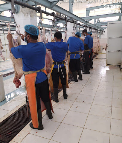
[toc]
The Oregon Coast Trail is a long hiking route running along the Pacific coastline of the state of Oregon. It starts at the Columbia river and works through to the California border at Brookings. The Oregon Parks and Recreation Department manage it. Many choose to cycle, walk, and hike along this beautiful route every day. The length of the Oregon coast trail in total is 425 miles.
You’ll find small coastal towns along the route, as well as parks, national forests, and, most importantly, public beaches! This is the perfect coastal trail to take even in the winter months as the view of the open shoreline is still just as breathtaking. Here, we have included a complete guide on how to hike the Oregon coastal trail, from what to pack, logistical planning, and safety. This hiking journey takes the average person about a month to complete, so you need to prepare for all hiking and camping conditions.
Where to start
The trail starts right in the North of Oregon at the Columbia River. The beginning point here is within Fort Stevens State Park. If you’re hiking the complete journey, you will finish at the California border, specifically at the Crissey Field State recreation site.
Terrain Conditions
As we have mentioned, the trail will take you through national parks, small towns, and public beaches. There will be many hours spent hiking along long stretches of the beach, so don’t expect much time spent in the wilderness. Part of the hike will include walking along the road. Usually, these roads are quiet, and all have pavements so you and your group can walk safely. You still need to take the usual precautions when walking along roads with traffic.
During this length of the route, it would help if you and your group wore bright colors and avoided walking in the dark whenever possible. If you begin your journey in the North, you will come across many stores, bathrooms, and other stops along the way. The further you move South, these stops will become few and far between. You must plan ahead for this and ensure you have all the supplies you need when hiking along the southern part of the route.
If you’re hiking when there are heavy rains, the rivers and creeks will swell, which can impact your safety on the route. During these times, some fords may even be impossible to cross. If so, you will need to come prepared to take alternative routes. Side roads are always an option when the water becomes high and too dangerous.
Places to resupply along the route
The great thing about the Oregon Coast route is that there are many places to stop for a rest, for the bathroom, and to restock necessities. There are many grocery stores along the trail! You don’t need to worry about running out of supplies while out on your hike. There are also many restaurants along the route should you wish to have a meal after a long day of hiking! There will be many spots for you to refill your water bottles. Make sure that you pack plenty of water filtration tablets for when you’re refilling from natural water fountains.
Weather
The Summer months of June through to September are the best and most popular time to take the Oregon coast trail. There is less rain and more sunshine, making the weather beautiful for hiking. With less rain, you will also be able to see the views much more clearly. Just think of the sun glistening off the water while you are hiking along the route! During this time, the water level of the rivers will be at their lowest, making the route a lot safer for you and your group. If you choose to hike during this time, you need to ensure you have packed plenty of water and sunscreen. You don’t want to become sunburnt or dehydrated on your long trek.
If you decide to trek the coastal line between November and April, ensure that you have sufficient gear and clothing to protect you from the wind and rain. During this time, it will rain a lot along the coast, and you can also expect some heavy fog and ocean mists from the waves along the beach routes. Even though the weather may sound terrible, this time of year is the best time to see incredible ocean views of stunning crashing waves.
Training
The hike along the Oregon coast will be incredibly draining for your body and your mental health. You must carry out the appropriate level of training before embarking on this long hike. Please do not attempt to hike the Oregon coast trail without training properly first. You will injure yourself, and you won’t be able to enjoy the hike at all.
Having the right amount of training behind you before you start your hike will ensure that you can enjoy it as much as possible, and you won’t have to worry about fatigue or injury! You should train gradually for a long enough period so that you can comfortably walk 6 miles without extreme fatigue or injury. Each day along the walk, you should aim to walk no more than five hours a day, and you should train accordingly to this.
Beach Safety
Although the route along the Oregon Coast Trail is considered very safe to hike, you still will need to be aware of possible dangers. Prepare to keep you and your group safe while out on the route. The most danger will occur while you are hiking along the beaches. The water along the coast can become quite wild at times. You need to respect – and be alert of – the changing tides. It would be wise to read up on some tide knowledge, and how the tides will move during the time you’ll be hiking.
Knowing the tide movements before you set out will ensure that you will be as prepared as possible for trekking along the beach route. This knowledge will be especially important if you plan to camp on the beach. Beach camping can be a magical experience when the weather is right, but it does have its dangers. Ensure that you know where the tides will be, and the behavior of the water before you set up camp. Along the route, there will be things called sneaker waves occurring. These unpredictable influxes of water can surprise even the most experienced of hikers.
There will be a few information centers along the route that will also be happy to give you information about the tides and water behavior during your time out there. You need to be careful while hiking to not walk along exposed rocks or eroded cliff sides. Take extra care while walking along the beaches, and you’ll be able to enjoy the amazing views with no issues.
Restrictions along the Oregon Coast Route
As with many hiking routes in the United States, the Oregon Coast trail will have certain restrictions depending on where you are along the route and what time of year you will be there. Throughout the summer months, and at certain points along the trail, you will be able to see the Western Snowy Plover. This is a small shorebird that forages and hides in the sand.
There will be restrictions in certain areas to protect these birds and their young during the time they are nesting along the beaches. During these times, you will not be permitted to have dogs, fires, or bicycles along the beach. You will also not be permitted to camp on the beach while the Snowy Plovers are nesting. You can check the Oregon Parks and the Creation Department’s website for information on where and when these restrictions will be happening.
Camping Spots
Beach camping along the Oregon coast trail can be a little complicated. It’s not permitted within city limits or state park boundaries. As mentioned above, it can also be pretty dangerous with the tides and water behavior. Almost every park you come across along the hike will have dedicated camping sites. With these camping sites, you will have bathrooms, showers and you’ll be near stores to stock up on necessities. It’s worth noting that many of these campsites are booked up months in advance, so plan early and get yourself a spot! There are around 19 camping sites along the coast, so you have plenty of choice on where to stay at night. Here is a list of some of the more popular campsites:
• Fort Stevens State Park. This campsite is right along the coast on the trail, so the scenes are very beautiful.
• Tillamook head. This campsite is part of the Tillamook Head national recreation trail and includes cabins with various rooms. This is a great campsite if you are traveling in a group.
• Nehalem Bay State Park. This campsite is right on the beach. In fact, it’s so close that you can hear the waves while you are falling asleep at night!
• Nehalem Falls Campground. This camping ground is dog friendly, and you can easily visit the falls from here.
What Gears to bring
Here is a long list of the gear that we recommend you bring if you are thru-hiking the Oregon Coast Trail:
• Rain Jacket
• Other rain-resistant clothing
• Waterproof coverings for your backpack and other equipment
• Hiking Boots
• Layers (heavy sweater for example)
• Compass
• Towel
• Toilet paper
• Hand Sanitizer
• First Aid Kit
• Trail map and hiking guide
• Plenty of water or water filter tablets
• Headlight
• Food bag
• Trash bags
• Tent
• Sleeping bag
• Toothbrush and toothpaste
• Sunscreen
• Sunglasses
• Hat
Now that you know how to prepare before your trip, here is a breakdown of the trail, section by section. You should print this guide and take it with you along the route. You may find yourself taking other side roads or paths when you are out there. This is just our guide for new hikers on the trail.
Northern Section of the trail
Start at the Columbia River in Fort Stevens state park. Follow the beach for around 16 miles. You will come to a beautiful seaside town for refreshments and bathrooms. Walk through Ecola State Park along the cliffside for around 8 miles to the next state park from this. Here, you will arrive at Oswald State Park. You may wish to camp within this park.
Next, take the US 101 to circumnavigate Tillamook Bay. Once you reach the other side of this beautiful bay, you can take a road right along the shoreline until you reach Cape Lookout State Park.
Once you are inside Cape Lookout State Park, you will pass through a forested route and then reach a beach shoreline again. Walk along the beach for around 10 miles. You will reach Nestucca Bay National Wildlife Refuge, and then there will be a further three miles of beach walking. You will then reach the Siletz River of Lincoln City.
The central part of the trail
From the Siletz River, follow the US 101 along cliffs of over 300 feet above the sea. The views here will be spectacular! Once you reach Beverly Beach, continue along the beach and cross the Yaquina Bay Bridge. Keep walking for around 15 miles until you get to Waldport. Once you reach Waldport, join the US 101 and cross the bridge on Alsea Bay. Keep going and, after you reach Yachats, take the US 101 until Carl G. Washburne State Park. You may wish to camp here for the night.
Walk along the beach for 6 miles until you reach Florence. Once here, you will have another 15 miles of beach walking with amazing views. The Jessie M. Honeyman Memorial State park will be near for you to camp for the night.
Southern Part of the trail
Catch a boat across the Umpqua River and then continue along the beach until Coos Bay. You can catch another boat across the bay, but remember to book in advance. After this, you will want to take the Seven Devil’s Road for around six miles. Take the coastline along the small seaside town of Bandon. This is a perfect place to catch some rest or a meal.
After this, you will walk along the beach again for around 15 miles. Following this, you should land on the cliffside of Cape Blanco for some amazing views. Continue on until you get to another seaside town called Port Orford. After this, keep going until you reach Humbug Mountain State Park, a perfect place to rest and camp for the night.
After Humbug Mountain State Park, you can follow the highway to Euchre Creek, and then there will be three miles of more beach walking. Arrive at the Pistol River viewpoint and walk along the beautiful trail until the next beach. Follow this through until you arrive at Harris Beach State Park.
And there you have our guide of hiking along the Oregon coastal trail route. Please remember that this is a general guide that is very popular among hikers along the trail. You may wish to take a few more detours on your journey. You must also remember to take a detailed map to ensure you know how to get to each of the points mentioned in this brief guide.
Why the Oregon Coast Trail is so popular
The Oregon coast trail is highly popular among hikers – even beginner hikers. It’s the perfect level for beginners who want to take their first thru-hike. Being able to do the entire hike in just under a month is very attractive to many people who don’t want to quit their jobs or take too much time off. Most of the Oregon Coast Trail is flat and at sea level. This means you will not have the burden of hiking while experiencing altitude sickness.
Your training will not have to be as rigorous as if you were taking a trail with a lot of uphill and downhill hiking. Along the Oregon coast, the weather is usually the perfect temperature for hiking also. Generally, it will never be too hot or sunny, so you don’t have to worry so much about dehydration or sunburn while out on the trek. As there are many camping spots along the route, you have plenty of options to rest while hiking the Oregon coast trail also.
And there you have our complete, comprehensive guide on hiking the Oregon coast trail. From the gear you need to bring, weather information, and recommendations on which routes to take, we have no doubt this guide will have helped to fully prepare you for your long and beautiful hike along the Oregon Coast! It’s important to remember that you will also need a certain level of flexibility while out on your hike. While this guide is comprehensive, certain routes may take you longer than imagined, or you may decide that you need extra time to rest up before embarking on the trek again.
Remember all the advice we have given you regarding safety and training to ensure that your trip will be as enjoyable as possible. You don’t want to worry about an injury in your group instead of taking in all the beautiful sea views you can experience! Enjoy the hike!